About Топогеодезия СК-42 light
Calculations of field topography in full or abbreviated coordinates, in one or in adjacent areas. Rectangular coordinates and heights in meters. Angles of directions and places in thousandths on a scale of 60-00 or 64-00....
Calculations of field topography in full or abbreviated coordinates, in one or in adjacent areas.
Rectangular coordinates and heights in meters.
Angles of directions and places in thousandths on a scale of 60-00 or 64-00. In OGZ and PGZ, the angles are also in degrees-minutes-seconds.
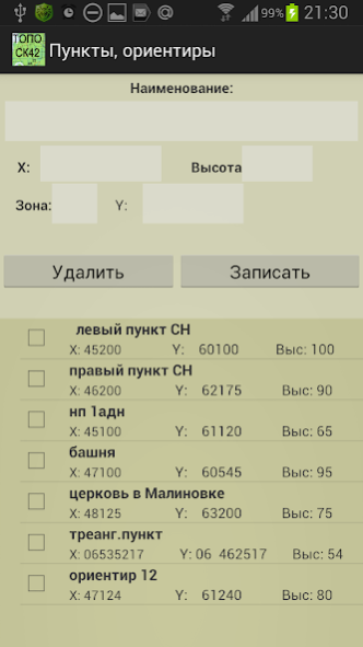
Maintaining a list of items whose data can be used in tasks (250). Saving data to a file / reading and adding data from a file. The file in xml / txt can be edited / prepared in text editors.
(Google / ArcGIS / TopBox / Off-line atlases) with point markers from the list (only with full coordinates).
Google Map is cached for offline use.
TopBox with Off-line manager in which you can load the visible area with the selected zoom levels. Maximum downloadable tiles maps 6000.
Atlases for off-line use in *. mbtiles can be created in SAS Planet, MobAC (only available in the full version).
When you touch the map, rectangular (in SK-42) and geodetic coordinates of the place are shown.
Coordinate grid (1 or 2 km) in SK-42. It is built around the first point on the list, 40x40 km.
Measuring distances on the map.
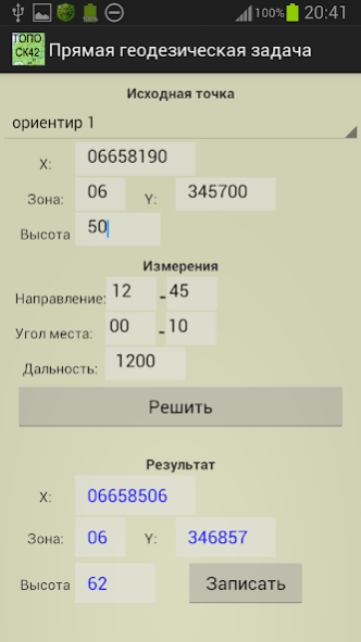
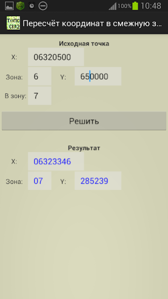
Composition of tasks:
- direct geodetic problem;
- inverse geodetic problem;
- recalculation of coordinates to an adjacent zone;
- sniffing by conjugate observation;
- binding with an undirected rangefinder;
- snapping by resection along the measured angles;
- referencing according to GPS data (geodetic and rectangular).
- azimuth of the star at a given time. For the Sun, for the Polar Star;
- nomenclature of the map sheet (specified scale for specified coordinates);
- notch with a stopwatch (taking into account the air temperature), screen stopwatch.
On the main menu screen to select
- scales of thousandths,
- Map service (Google, ArcGIS, Mapbox, Offline Atlas)
- interface color style
- the type of point markers on the map
- temperature (C / F)
- saving data to a file / reading and adding data from a file.
Free (light) version limitations:
- a list of 4 points (instead of 250);
- on the map a small area of the grid;
- several tasks and functions are disabled.
- no work with off-line atlases.
The free version also has some ads.
The program is distributed "as is". Its use is at the discretion and responsibility of the user.
Previous Versions
Here you can find the changelog of Топогеодезия СК-42 light since it was posted on our website on 2023-03-03 22:53:45.
The latest version is 2.9.3 and it was updated on 2024-04-22 16:37:09. See below the changes in each version.
Топогеодезия СК-42 light version 2.9.3
Updated At: 2022-06-13
Changes: 1. Выбор цвета маркеров пунктов. Сортировка списка пунктов.
2. Записи в списке пунктов с контекстным меню
3. Возможность ввода координат пунктов в WGS
Disclaimer
Official Google Play Link
We do not host Топогеодезия СК-42 light on our servers. We did not scan it for viruses, adware, spyware or other type of malware. This app is hosted by Google and passed their terms and conditions to be listed there. We recommend caution when installing it.
The Google Play link for Топогеодезия СК-42 light is provided to you by apps112.com without any warranties, representations or guarantees of any kind, so access it at your own risk.
If you have questions regarding this particular app contact the publisher directly. For questions about the functionalities of apps112.com contact us.